


YOUR LOCAL AERIAL EXPERTS FOR ALL THINGS
D R O N E.
Serving the Tri-Cities and surrounding areas


FAA Certified
Part 107 ● 137

Licensed ●Bonded ● Insured
Proudly Serving the Tri-Cities, WA

Altitude Ag and Altitude Aerial are rooted in the Tri-Cities area. With a home base in Richland, nowhere in the Tri-Cities Area is too far to fly. With professional pilots, precision aircraft, and intense safety standards, every flight - from simple aerial photography to complex spray operations. We strive to achieve the best outcome for whatever drone services you need. No job is too small or too large for our team.
.png)

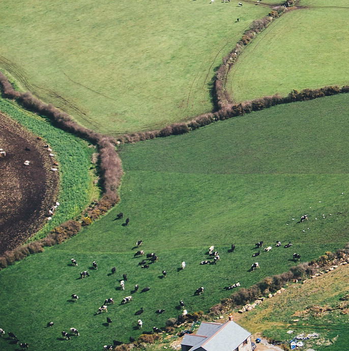
Our ag team works around the clock to cover the acres you need sprayed. We are proud of our drones capabilities to apply the best rate for every scenario - and you may be surprised how much product you can save with our increased efficacy. Low altitude flights to minimize drift, strong downdraft to maximize coverage, and precision mapping to cover every last inch of your fields.
Our imagery team is a special curated crew of film and cinema experts, striving to capture the highest quality images and video for all of your aerial photography needs. We hold a combined 2500+ hours of various types of flights from fast paced FPV drone video to slow and steady construction progress.
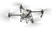
If watching other people fly fun toys isn't your thing, we can help you out! As a DJI Certified Dealer, we can get you the best price for a number of the top DJI drones. From a simple camera drone to a sophisticated spray drone or anything in between - get a hold of our dealer team and take to the skies!


CUSTOM SPRAYING
& SEEDING APPLICATION

Herbicide
Pesticide
Insecticide
Aerial Herbicide Application
Aerial Pesticide Application
Aerial Insecticide Application
Cover Crop
Fungicide
Fertilizer
Aerial Fungicide Application
Aerial Fertilizer Application
Aerial Cover Crop Application
.jpg)


Our ag team works around the clock to cover the acres you need sprayed. We are proud of our drones' capabilities to apply the best rate for every scenario - and you may be surprised how much product you can save with our increased efficacy.
Ideal for both flat land areas and unfavorable terrain, hard-to-access areas, test plots, field edges or anywhere else precision application methods are needed, AAS will deliver timely application even after adverse weather conditions.

Irrigated Row
Crop Operations
Leverage crop and field data established by your agricultural data platforms. We deliver inputs precisely when and where they are needed. Liquid or dry applications, we have it covered. From pesticides to micronutrients, inter-seed cover crop seeds, and even deployment of beneficial insects.
Dryland Crop
Operations
Ideal for both flat land areas and unfavorable terrain, hard-to-access areas, test plots, field edges or anywhere else precision application methods are needed, We deliver timely application even after adverse weather conditions. Drones eliminate soil compaction, crop damage and wasted product.
Private
Industry
Drones can play a key role in the crop insurance industry, at both the pre-and-post-claim stage. Using a drone helps for site inspection, claims decisions, fraud prevention, and risk management. We also work with the renewable energy industry doing inspections on wind turbines, solar farms, and pipelines.
Local, State and
Federal Agencies
We partner with governmental agencies on a local, state and federal basis to provide services that benefit the communities they serve. Working with the requirements and guidelines that these agencies work under is our specialty.
Orchard & Vineyard
High-value, low-acre specialty crops, such as orchards, berries and vineyards. Spot spraying, site specific applications, and hard to access areas are ways to utilize drone applications for commodity crops. We also specialize in moisture abatement for your high value crops.
AERIAL
LOST PET
+ LIVESTOCK
SEARCHING

Dogs
Cats
Livestock
Aerial Lost Dog Search
Aerial Lost Cat Search
Aerial Livestock Search
Tracking
Thermal
Zoom
Thermal Search Capabilities
112x Zoom Capability
Automated Tracking Capability


When time matters most, our aerial search services provide rapid, efficient coverage to help locate lost pets and livestock. Utilizing thermal imaging and powerful zoom capabilities, we scan large areas quickly — even in low-light conditions — to detect heat signatures and movement that may not be visible from the ground.
From missing dogs and cats to displaced livestock across large properties, AAS brings advanced aerial technology to assist in safe and organized search efforts. Our systematic approach increases search coverage, improves visibility in difficult terrain, and gives owners added confidence during stressful situations.


Fast
Dispatch
When time is critical, rapid response makes the difference. We prioritize urgent calls and deploy quickly to begin systematic aerial search operations, increasing the chances of locating lost pets or displaced livestock as soon as possible.
Thermal
Capability
Advanced thermal imaging allows us to detect heat signatures in low-light conditions, wooded areas, tall grass, and uneven terrain. This capability significantly improves visibility beyond what is possible from ground-level searches.
112x
Zoom
High-powered 112x zoom enables detailed visual identification from a safe distance. Whether scanning open fields or inspecting distant tree lines and structures, enhanced zoom capability improves confirmation and tracking accuracy.
Automated
Tracking
Intelligent tracking technology allows the drone to lock onto moving subjects when detected. This feature helps maintain visual contact while coordinating safe and organized ground response efforts.
Livestock
Monitoring
Ideal for ranches and agricultural properties, aerial monitoring assists in locating, counting, and observing livestock across large or remote areas. Drone coverage improves efficiency while reducing manpower and ground travel time.
Daytime Rates
PRICING
$125 first hour
$100 per hour
thereafter
Nighttime Rates
$175 first hour
$100 per hour
thereafter
*Applicable tax and credit card
fees apply
*Livestock rates can vary - please contact for more info
AERIAL
PHOTOGRAPHY
+ VIDEOGRAPHY
SERVICES

Real Estate
Promotions
Land Capture
Events
Weddings
Cinematics


.png)
Real Estate Photography
Promotional Drone Videos
Drone Property Capture
Aerial Wedding Footage
Professional Aerial Videography
Drone Services for Any Event
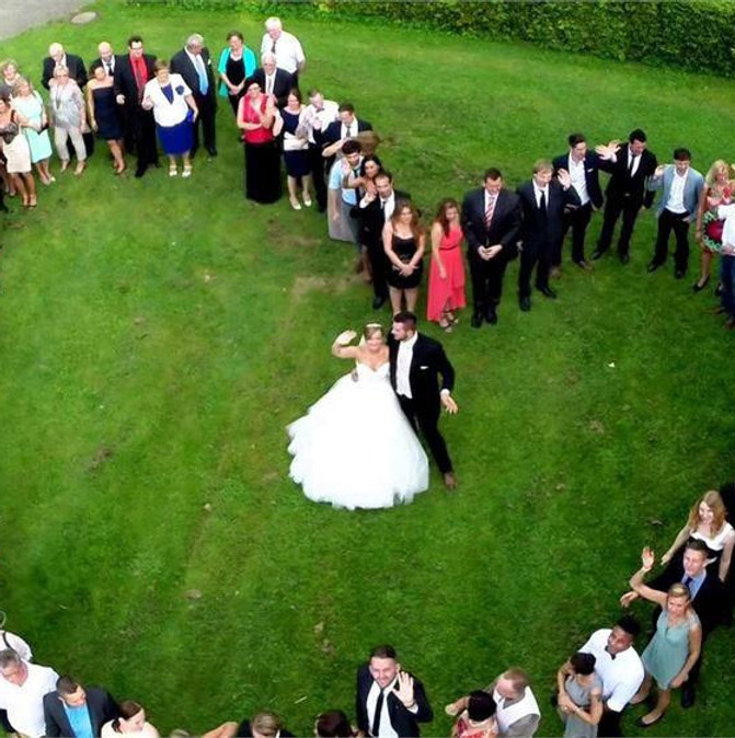
Our aerial media team captures stunning, high-resolution photos and cinematic video designed to showcase your property, brand, or special event from a perspective that stands out. From real estate listings and promotional campaigns to weddings, land marketing, and large-scale events, we deliver clean, stabilized visuals that elevate your story and leave a lasting impression.
Whether you need dramatic cinematic footage, detailed land capture, or dynamic event coverage, AAS provides professional-grade results with fast turnaround times. We work efficiently, safely, and creatively to ensure every angle highlights the features that matter most — helping you attract buyers, impress clients, and preserve unforgettable moments.

Real Estate
Listing Imagery
Showcase residential, commercial, and rural properties with high-resolution aerial imagery. We capture listing photos, cinematic walkthroughs, and land overviews that highlight boundaries, features, and surrounding amenities. Professional aerial visuals help attract buyers, increase engagement.
Business
Promotions
Elevate marketing campaigns with dynamic drone visuals designed for websites, social media, and advertising. From storefronts and facilities to large campuses and projects, we provide compelling aerial content that strengthens brand identity and captures attention with modern, professional presentation.
Weddings &
Events
Capture unforgettable moments from a breathtaking perspective. Our aerial coverage complements traditional photography by documenting venues, guest gatherings, and scenic backdrops with smooth cinematic motion. We work discreetly and safely to enhance your event coverage without disruption.
Land Capture
& Framing
Ideal for large parcels, development tracts, farms, and recreational land. We provide wide-area capture that clearly defines property lines, terrain features, access roads, and natural highlights — delivering valuable visual tools for marketing, documentation, or investor presentations.
General
Cinematics
From short films to creative productions, our drone capabilities deliver smooth, stabilized footage for storytelling and visual impact. We collaborate with clients to execute precise flight paths, dramatic reveals, and detailed capture tailored to your project vision.
ROOF +
INFRASTRUCTRE
INSPECTIONS

Roof
Tower
Solar
Aerial Roof Inspection
Aerial Tower Inspection
Aerial Solar Inspection
Power Line
Bridge
Building
Aerial Power Line Inspection
Aerial Building Inspection
Aerial Bridge Inspection


Our drone inspection services provide a safer, faster, and more cost-effective way to evaluate roofs and critical infrastructure without ladders, lifts, or shutdowns. From residential and commercial roofs to towers, solar arrays, power lines, buildings, and bridges, we capture detailed imagery that allows you to assess condition, identify damage, and plan repairs with confidence.
Ideal for routine maintenance, storm assessments, and pre-purchase evaluations, AAS delivers clear visual documentation that reduces risk and minimizes disruption. Our aerial perspective allows us to access difficult or hazardous areas while keeping crews safely on the ground — saving time, lowering liability, and improving overall inspection efficiency.
.jpg)


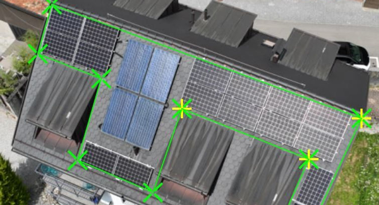
Res. Roof
Inspection
Safely assess shingles, flashing, vents, and overall roof condition without ladders or foot traffic. High-resolution imagery allows property owners and contractors to identify damage, leaks, and wear while minimizing liability and disruption.
Comm. Roof
Inspection
Large commercial roofs can be inspected efficiently with aerial imaging that documents membrane condition, ponding water, penetrations, and storm damage. Drone inspections reduce downtime and provide detailed visuals for maintenance planning and insurance reporting.
Solar + Line
Inspection
Inspect solar arrays, power lines, and energy infrastructure with precision and efficiency. Aerial imaging allows operators to monitor panel condition, line clearances, and structural integrity while reducing operational interruption and access challenges.
Cell Tower
Inspection
Evaluate communication towers, stacks, and elevated structures without climbing crews. Our drones capture close-range imagery for structural review, surface condition monitoring, and routine inspection while keeping personnel safely on the ground.
General
Inspection
Document structural elements, facades, and hard-to-access areas on bridges and large buildings. Drone inspections provide clear, actionable imagery for engineers, facility managers, and municipalities seeking safer and more cost-effective assessment methods.
SMALL +
LARGE AREA
MAPPING
Construction
Field
Parcel
Aerial Construction Progress
General Aerial Mapping
Aerial Parcel Mapping
Residential
Vineyard
Urban
Aerial Vineyard Mapping
Aerial Urban Mapping
Aerial Residential Mapping
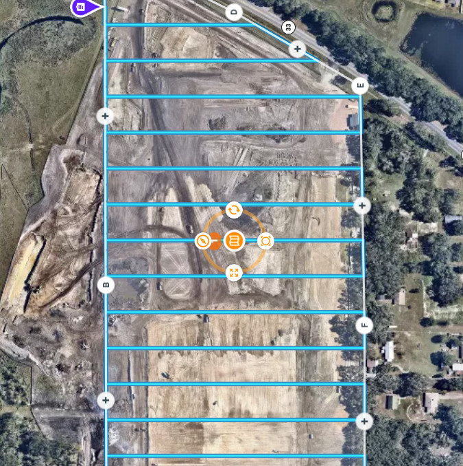


Our mapping services provide accurate, data-driven aerial insights for projects of all sizes — from small residential parcels to large construction sites, agricultural fields, vineyards, and urban developments. Using advanced flight planning and imaging technology, we generate high-resolution orthomosaic maps and detailed overviews to support planning, measurement, and progress tracking.
Whether you’re managing a construction timeline, documenting field conditions, or analyzing land development, AAS delivers reliable mapping data you can use with confidence. Our streamlined workflow ensures timely delivery and precise results, giving you a comprehensive view of your project from start to finish.


Construction
Progress
Track site development with high-resolution orthomosaic maps and consistent aerial updates. Monitor grading, material placement, and project milestones with accurate visual documentation that supports reporting and timeline management.
Field
Mapping
Capture detailed aerial overviews of fields, vineyards, and specialty crop areas. Mapping services provide clear visual references for planning, drainage evaluation, and seasonal documentation across both small and large acreages.
Vineyard
& Orchard
Our aerial mapping provides detailed overhead imagery to support crop planning, irrigation management, and seasonal evaluation. High-resolution orthomosaic maps help identify row alignment, canopy density, drainage patterns, and access routes across high-value specialty crop operations.
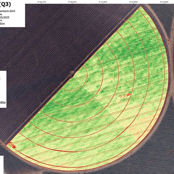
NDVI
Maps
NDVI mapping allows growers and land managers to assess plant health using advanced vegetation index data. By identifying stress patterns, variability, and growth inconsistencies early, these maps support informed decision-making, targeted input application, and improved overall crop management efficiency.
Large-scale
Area Capture
Ideal for expansive properties, industrial facilities, and multi-acre projects. Our systematic flight planning ensures comprehensive coverage and consistent image quality across broad areas requiring precise visual documentation.
DJI CERTIFIED LOCAL DEALER
Drones | Accessories | Parts | Setup | Maintinence
Explore our store:

Stock can vary - please request a quote if you're interested in any products


Stock can vary - please request a quote if you're interested in any products
Contact Us!
1333 Tapteal Drive #107
Richland, WA 99352
509-551-4774
509-551-4383
COMPLIANCE
We take great pride in our commitment to excellence and quality. Our dedication to delivering the best services is backed by a range of industry certifications. These certifications validate our expertise and ensure that we meet the highest standards in the field of agricultural services. We continuously strive to provide cutting-edge solutions to our clients, and our certifications reflect our unwavering commitment to your success.
EDWOSB Certified
FAA Part 173 Certified
Licensed, Insured, Bonded
FAA Part 107 Certified
RID Compliant
NIST Tested
DIU Blue UAS Compliant
WSDA & ODA Licensed
SBA Certified
Equal Opportunity Employer

Our Team

Melody Beckley
Co-Owner

Kurt Beckley
Co-Owner | Pilot

Jacob Morfin
Pilot


Danner Breault
Pilot
Drew Castellaw
Pilot